Technology
Flight-schedule of satellites and data coverage
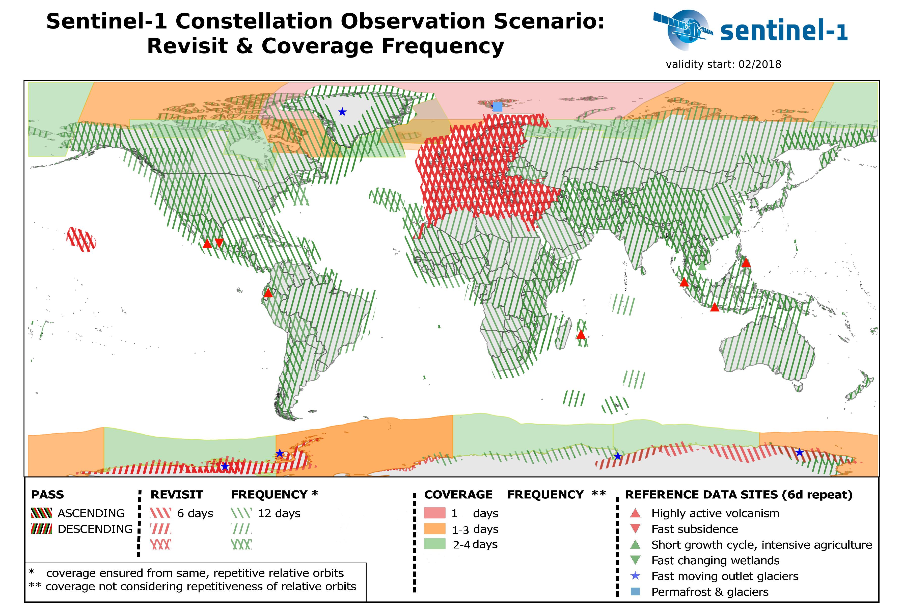
Sentinel-1, carried out by the European Space Agency Copernicus Programme, is a space mission designed as a two-satellite constellation. This means that two satellites, Sentinel-1A and Sentinel-1B, share the same orbit - but 180 degrees apart. While one satellite can orbit the Earth in 12 days, both satellites operating together provide a 6-day repeat cycle. Areas around the equator see the satellite repeat in just three days, Europe and Canada in less than three days, and Arctic areas in less than one day.
Considering the Sentinel-1 and 2 flight schedule, we can't assure same data covergae and regularity for the whole world. Revisit and coverage frequency limitations are shown on the map below:
What is point cloud density and why is it important?
A point cloud is a set of data points in an area of measurement. Point density describes the number of points in an area of measurement. Therefore, the higher the point cloud density, the more data or information is available in the measured area. Higher point density means you will get a more detailed image because there is more information available.
Differences between LiDAR and SAR
| LiDAR | SAR |
| Weather dependent (blocked by cloud coverage) | Continuous coverage (see through clouds) |
| Extremely high-resolution data allowing for detection of forest density or minor construction flaws | Observes progression of surface deformation - ideal for analyzing structural health of infrastructure and future maintenance planning |
| Airborne - ability to choose when and where to collect data | Space borne - data collected at pace and path of satellite orbit. (SAR can also be airborne) |
| Predefined area of interest | Monitors area in orbit path |
| Type of spectrum: infrared | Type of spectrum: microwave |
| Single-frequency | Multi-frequency |
LiDAR requires an aircraft flight making it a costly option and weather dependent. SAR technology is acquired through an orbiting satellite that is more cost effective and can penetrate through cloud coverage. Both are able to acquire images during day or night. LiDAR provides very high-resolution data allowing detection of forest density or minor construction flaws. SAR observes the progression of surface deformation by utilizing multiple data sets of the same area over time.
Differences between GPS and SAR
| GPS | SAR |
| 24-hour monitoring | Trends over time |
| Defined area of interest | Large scale areas (up to 10,000 km2) |
| Immediate need for information | Long-term coverage of an area providing bi-monthly information |
| Requires physical presence on the ground (receiver) | Ability to monitor anything without predefined location |
SAR and GPS can often work in tandem, complementing an overall effort to keep public and private infrastructure closely monitored and stable. While GPS can produce daily analysis of an specified area, SAR is able to give comparisons of historic and current data to offer displacement data over time. This can serve as necessary information when deciding to utilize more costly measurement options.
- SAR relies on orbiting satellites that are able to observe deformation without needing a ground receiver. GPS relies on ground receivers to transmit information.
- SAR collects detailed information of a large area at one time. GPS is not able to collect dense large-scale data quickly.
- SAR provides the relative amount of deformation. GPS measures the absolute amount of deformation.
- Initially, SAR requires analysis of at least 20 images to conclude deformation information. Following initial analysis, one-on-one images can be used. Images are taken of the same location at different times. Because of SAR's satellite orbits, locations cannot be observed 24 hours using SAR, but every 12 days. GPS is able to continuously monitor an area because of multiple satellites acquiring data.
- SAR measures the distance from the satellite to a target on the ground and back to the satellite by sending out one assessment beam and measuring its distance. GPS monitors the distance from a satellite to ground receiver.
- SAR measures ground deformation in the line-of-sight (LOS) direction that requires two images of the same area on the ground at different times. GPS is able to observe 3-dimentional deformation because of multiple satellites acquiring data from different directions at the same time.
- SAR satellites orbit the earth about every six days, allowing some areas of the earth more frequent coverage, some less. SAR acquires data when it is above a target area, and requires two images to conclude information, allowing for high-density observation data about every two weeks. GPS is possible 24 hours because it does not rely on specific satellite rotations.
What objects can be succesfully monitored with SAR?
SAR can be used to monitor objects that have good reflection. Usually these are buildings, railroads, bridges, bare land, rocks, docks, piers, dams and other human built objects. Bare slopes can be also monitored for falling rocks and landslides, as well as landslides. The ideal objects to monitor using SAR include a rough surface, like concrete, rock, or metal, and have many corners, which reflect very well. However, objects made from wood or other non-reflective surfaces, long suspension bridges and other small objects are not ideal for SAR to monitor.
What does SAR do?
Interferometric synthetic aperture radar (InSAR) is a space-borne (or, alternatively, airborne) microwave imaging system that can be used to generate maps of ground deformation. Ground deformation is the movement of the Earth’s surface caused by seismic strain, landslides, and mining or landfill activities.
SAR can provide a historical analysis of ground movement that can be used for infrastructure monitoring. Acquiring frequent (bi-monthly) infrastructure displacement measurements can serve as an early warning system for possible infrastructure malfunction or failure. This allows prioritization of vehicle- and person-based inspections, thus reducing cost and increasing efficiency of maintenance planning.
What is InSAR?
Synthetic aperture radar is a method of observation utilizing satellites and surface deformation monitoring technology.
Description of InSAR: Differential and Persistent Scatterer SAR Interferometry
Differences between LiDAR and SAR
LiDAR SAR Weather dependent (blocked by cloud coverage) Continuous coverage (see through clouds) Extremely high-resolution data al...
Read moreOutput of the application
Satellite line-of-sight
Basic displacement information provided by the service is the satellite line-of-sight (LOS), with projected to ground geometry and quality measures pe...
Read moreMethodology
SAR
The main source of information for deriving ground motion data are Synthetic Aperture Radar (SAR) data from the ESA Copernicus Sentinel-1 mission. Th...
Read moreThe Data
Sentinel 1
Sentinel-1 routinely collects data in three modes: Interferometric Wide Swath (IW), Extra Wide Swath (EW) and Wave (WV). The latter two are used for m...
Read moreHistory
About InSAR
Synthetic Aperture Radar Interferometry (InSAR) is the main technology for space based ground motion measurement. It has been in use for more than 25 ...
Read moreApplication
Data Delivery
This service offers analyzed data in powerful yet simple to operate visual mapping application. SILLE enables data analytics, comparison, reporting an...
Read moreSille uses InSAR satellites
Sille uses European Space Agency Interferometric synthetic aperture radar (InSAR) satelite Sentinel-1 to gather information. What is InSAR? InSar is...
Read more